


RACE ROUTES
Like the 2026 race, we won't have an overall podium decided by the cumulative total time for Saturday and Sunday. Instead, we'll have separate races each day, which will allow riders to compete even if they can't race both days.
SATURDAY we'll have two race routes. The long route is 70 miles with 8100 feet of climbing, and the short route is 46 miles with 5600 feet of climbing. Both routes feature some of the best scenery the Cherokee National Forest has to offer, with cascading creeks and waterfalls, a stunning 360-degree view at the top of Buck Bald, and a beautiful start along the Hiwassee River. While there's no avoiding chunky sections in the forest, the race routes avoid the worst roads and are doable on a gravel bike.
For SUNDAY, rather than give you another long race of attrition, we'll have a race that feels like a race, with a faster pace and tighter competition. So we're offering just one relatively short route - the Sunday Sprint! - with 28 miles and 3700 feet of climbing. In addition to racing at a different heart rate zone than Saturday, the Sunday Sprint will also allow you to wrap up the weekend a little sooner if you need to get on the road to head home. (We anticipate podiums taking place before noon.) Like Saturday, the route will have some chunky sections but is doable on a gravel bike.
PLEASE NOTE: While we're happy to provide a bailout option on Saturday's 70-mile route (which comes at mile 39 and gives you 46 miles for the day), if you start with the 70 milers and then take the bailout, you will NOT be eligible for the podiums for the 46-mile race even though you will have completed the 46-mile route. (Your time will also be noted differently on the final results to distinguish it from the 46-mile racers.) If you want to race the 46-mile route and be eligible for the podiums at that distance, you must start with the 46-milers.
RECREATIONAL ROUTES
The Saturday and Sunday rec routes are the same as previous years, with a beautiful 24-miler on Saturday and a slightly more challenging (and rockier) 26-miler on Sunday. While these routes are not considered race routes and will not have podiums, they're not a walk in the park either, with around 3,000 feet of climbing each day. Gravel bikes are appropriate for both routes, as are hardtails (which will make Sunday's bumpy descents a little more enjoyable).
CATEGORIES & AWARDS
Podium awards and cash prizes will be awarded to the top 3 finishers for the following categories in Saturday's 46-mile and 70-mile routes and Sunday's 28-mile route.
-
Men's Open
-
Women's Open
-
Men's Masters (45-59)
-
Women's Masters (45-59)
-
Men's Grand Masters (60+)
-
Women's Grand Masters (60+)
-
Single Speed
-
Juniors (18 & under, male) (no Junior podium for 72-mile route)
-
Juniors (18 & under, female) (no Junior podium for 72-mile route)
The first place winners in each category will also receive a special prize from TEREN Designs and also a free entry to next year's event so that they can defend their titles!
TIMING & CHECKPOINTS
Although the recreational routes will not have podiums, all of the routes will be timed with results posted for each distance. All riders must STOP at the timing table at the finish line each day to ensure that their time is properly noted. In addition, everyone riding the 46 and 70-mile routes must STOP and check in at the aid station at the top of Buck Bald, and everyone riding the 70-mile route must STOP and check in at the aid station at the top of Starr Mtn. If you don't stop at the checkpoints and at the finish line, then we won't be able to give you a finishing time. There are no checkpoints for Sunday's routes.
SUPPORT CUTOFF
There are no cutoff times this year, but there are closing times for the aid stations and for the sweep vehicles. So if you plan to ride all day on Saturday, make sure you are fully self-sufficient in case our volunteers have already packed up. Please note the following closing times for the Saturday aid stations. Also please note the distance between aid stations and plan accordingly.
-
McFarland (mile 15): 10:00
-
Buck Bald (mile 26): 11:30
-
Starr Mtn (mile 48): 1:30
NAVIGATION
The routes will NOT be marked. It is therefore imperative that you download the routes before you arrive at the event by clicking on the maps below.
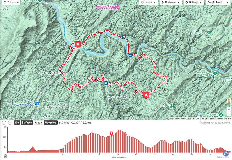
SATURDAY
24 Miles | 3,000 Feet of Climbing | 70% Gravel
-
Although the distance is relatively short, this route packs a punch, with plenty of climbing & descending on the Powerhouse climb and Lost Creek Road. It also provides the perfect introduction to the beauty of the Cherokee National Forest!
-
An aid station with nutrition & hydration will be available at mile 11.
-
Click below for a downloadable map.


SUNDAY
26 Miles | 2,700 Feet of Climbing | 50% Gravel
-
Like Saturday's short route, this 26-miler is much tougher than it sounds, with a hard 3-mile climb up Kimsey Mtn Hwy early in the ride followed by a series of short, steep climbs & descents on the rowdy Piney Flats section.
-
An aid station with nutrition & hydration will be available at mile 15.
-
Watch for the left turn onto Piney Flats around mile 9 and also the left turn onto Powerhouse around mile 17. They're both easy to miss!
-
Click below for a downloadable map.

